“Great, everyone’s ready!” my team leader for Mt. Batur expedition exclaimed excitedly.
There were eight people that day planning to climb Mt. Batur. The team’s coming from different outdoor activity clubs in my place, Singaraja, Bali.
“Alright, please check your gears and once we’re ready, we leave for a three-hour journey to the mountain’s first climbing post,” my team leader, Iwan, ordered.
At around 10 in the morning, everyone’s ready. Then, we went to catch the public transport to Kintamani, a place where magnificent scenery overlooking to a currently active Mt. Batur, a green shady Lake Batur, and an old Bali village, Trunyan. I should tell you some brief information about these places before continuing my story. To me, this over a decade life experience is something good to cherish :)
***
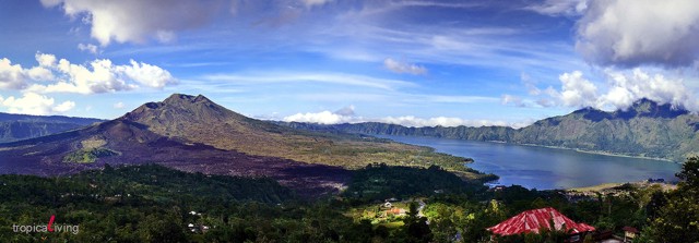
Mt. Batur

According to Wikipedia, there are ten mountains in Bali. They are (in order of heights above sea level) Agung (3,148 m), Batukaru/Batukau (2,276 m), Abang (2,151), Catur/Catu (2,096 m), Sengayang (2,087 m), Pohen (2,063 m), Lesong/Lesung (1,865 m), Adeng (1,826 m), Batur (1,717 m), and Prapat Agung (322 m). All the mountains in Bali are the end of the strings of the volcanoes that make up the ring of fire that stretch all the way from the Asian continent to Sumatera to Java. Most of these mountains are located in the northern part of Bali.
Apparently, Mt. Batur is the ninth-highest mountain in Bali with a 1,717 (easy to remember :)) in height above sea level (5,633 ft), located in the north-central of Bali, in Bangli regency where I spent some years of childhood earlier. What is fascinating about this mountain is that it is a mountain inside a mountain – a subsequent mountain (like Krakatoa). Considered as an active volcano, the current Mt. Batur is the remains of a cataclysmic prehistoric eruption (about 28,500 years ago) of a volcano (reported to be over 4,000 m above sea level). Because it has frequent eruptions over the last two centuries, it is regarded as the most active volcano in Bali. Even once, I climbed the mountain when it erupted (small portions in its slopes on the south west of the mountain). Now, by the time I am writing this I realized, our climbing days last time were dangerous! :)
Apart from its frequent activities, Mt. Batur is a very popular trekking mountain among tourists and climbers since it is a fairy straight forward trek to the top. There are basically three parts you will find when climbing this mountain; heavy forest, reddish lava rocks, and savannah. The mountain’s top then has a steep edge overlooking the caldera and slopes in your left and right. However, it is free from forests. Thus, it may offer spectacular views to surrounding objects, such as Mt. Abang and Mt. Batukaru, Lake Batur, and Trunyan, an ancient Balinese village.
Lake Batur

Lake Batur is another fascinating view to enjoy either from the lake itself or from the top of the mountain. Together with other three lakes (Beratan, Buyan, and Tamblingan), Lake Batur is the largest in Bali. All the lakes are all up in the highland. Lake Batur is adjacent to Mt. Batur. It is a 10×13 km caldera lake (another smaller 7.5 km caldera is in the subsequent mountain) containing a rich source of fish. The main villages populating the caldera are Songan, Kedisan and Toya Bungkah. The latter has a fine hot spring where you can shower in a hot bath, giving you the most comfort in its cold weather. Moreover, there is also an art center built in 1971 by Sutan Takdir Alisjahbana, a North Sumatran novelist, philosopher, and painter. He is famous with “Layar Terkembang”, a novel published in 1936.
Trunyan Village

Across the lake, lies the village of Trunyan where Bali Aga (the original descendants of Balinese) people live. These people were to precede the arrival of the Hindu Majapahit kingdom in the 16th century. What is unique from this village is on their cremation custom. Rather than cremating or burying the dead as what most Balinese do, they lay them in bamboo cages to decompose. Strangely, there was no smelly odor coming out from the corpse. It is believed that the large Taru Menyan trees in the surroundings hinders the smells, for they produce fragrant scents. That’s why the village’s name may originate from these two words; Taru means ‘tree’ and Menyan means ‘pleasant smell’ giving ‘Terunyan’ (Trunyan) a name for the village. Like the other Bali Aga villages, the villagers speak a specific variation of the Balinese dialect of its own.
***
As you can see, the place has many beautiful surroundings to visit. To continue my story, we arrived in the area at around 2 p.m. This was after persuading the driver to go down the steep road down to Toya Bungkah, a hot spring resort at the foot of the mountain. After getting off the cab, we looked for a ‘comfortable’ place to set up our camp. The evening soon came and we needed to take a rest for the real journey tomorrow; early morning. At the bottom of the mountain, all we could see were lands with grass on the rocks. Mountain rocks. Sometimes, the colours are reddish, covered with reminiscent of melted lava from the previous eruptions. We had to spread our sleeping mattress. This was the time to practice our bivouac as a part of our survival skills.
In the evening, we kindled fire to warm our bodies. Our paraffins were burned in a small stove we brought specially for outdoor activities. Nastings – aluminium pots – cooked our ‘delicious’ food. Outdoor activists must know that by delicious, I meant noodle, and other very practical types of meals. The smells of the food caught our nose and slightly filled in our hungry stomach. While having our dinner, the group chatted and laughed for jokes. We sometimes reviewed our plan for tomorrow’s climb. After having enough, we prepared to have a rest. We entered our dome tents and got ready to sleep under the sleeping bags for the temperature when sleeping outdoor, under the starry sky is always low, especially when it’s on the foot of a mountain. After having a few more chats, we slept. You know, it’s always not easy to sleep not in a comfortable place, say like in a bed. Our base is the land with some mountain rocks. It needs frequent outings to get used to this. And fortunately, we did several climbs and other hikings prior to this climb.
The next morning, at around 3 a.m., we got up and unpacked the tents and our belongings. It’s done pretty quickly. We stretched our bodies for around 15 minutes to get warmed up. We once again reviewed the climbing plan and started to take the path. Some snack and drink sellers were already sitting in the first climbing post. They seemed as eager as we were to climb the mountain. Certainly, their motive was simply to sell and got as much as money from us the climbers. What interests me was that they probably climb the mountain everyday. This could be very easy then for them!
With our large carrier bag, we started to follow the path. It was still dark, so we used our torches to help walking the way. It’s still plain with some wuite challenging paths in the middle. We were in basically two groups of four. We used the compass to guide us to the right climbing path. On the foot of the mountain, the climb was still manageable. The road, though small, was still plain so it did not really cost our energy. The real struggle started when we reached the slope of the mountain. The path began to go up. Mount Batur is said to be one of the interesting climbs. It started with thick pine tracks then plain red rocky path. After this, you’ll meet the challenging sandy track that could be very frustrating before you meet the savana-like track that directs you to the top. This savana-like area would also have the famous Edelweiss and its search (just to see – not to pick them as they are protected by the government) is always one of the most memorable journeys to cherish.
The tricky part is the first. As tracks were shrouded by pine tress, we have to be really careful to follow the right path to the top. It is always still dark when climbers wander in this track. Many times, lots of them got lost in this first challenge. And this happened to our group. We were separated from another group of friends because we followed a different direction.
It was when we slowly heard faded away chatters that we managed to realize this. Not in front of us but somewhere in our right direction. We tried to call our friends and we confirmed ourselves that we’ve been separated. The problem was, we were separated by something like a valley that we didn’t even know its depth. We still could hear their chats and shouts. It was pretty dark that time and our choice were to go back or to cut short through the possibly deep valley. The first choice would waste our time and we probably would not be able to reach the top before sunrise. The second, however, was shorter but had dangers we didn’t know yet. Even so, we decided the second. It was probably the young blood rushing.
With us, a 2 metre pole, a standard rope, two combat knives and torches. We had to take risk to go down to the very steep valley we didn’t know its depth yet. It could be very very deep. It could be not. We tried to to use our pole but it didn’t seem to reach any end. It must be deeper than 2 metres then. Even worst, we tried using the pole and tested our hearings when it reached the ground but it was pointless. We lost our pole and no sound heard. One of my friends, Kris, jumped first. It was a moment of uncertainty for a moment for all of us as we didn’t know what would happen next.
Gut was the answer.
He assured, he would tried to go down slowly. We used our carrier bag tied in the rope. He tried, full of effort, to find ways to go down the valley. But suddenly, he went down fast! With quite a soft ‘bukkk’ sound, we heard nothing. Silence.
We called and called. No sounds from him. We were very worried. Then we heard a slow, fainted voice saying that he was alright. We were glad. He told us to go one by one. All of us had the same ‘bukkk’ sound when landed even though we tried to go slowly. It was too steep that we couldn’t stop from going down fast. We looked each other. Counted each one to make sure all of us were there; complete. After being assured that everyone was safe, we realized the deep part of the valley was another challenge. Darkness; no path. This was when our combat knives should be used. We cut and cut, making our way while keeping our focus to our friends’ call in another pathway. It was quite a journey, and luckily everyone was alright.
After 15 minutes, we finally reached our friends’ place. Going up was not really a problem as we were helped by this other group. What an experience! But we were still far from the top. This is only the first part of the climb for all climbers. After taking a rest, we continued climbing. We moved fast, much faster than usual as we lost some time earlier. We tried to meet the sun at the top. We reached the end of the pine forest. The mid part of the mountain is now covered with reddish rock. We saw rocks everywhere. No trees.
The rocks presented another challenge. As they were from the remnants of the eruption, they could be very unstable to step on. We had to be very careful then. We only followed the path made by foot steps of the previous climbers. The reddish lava reminiscents gave a spectacular view though. It must be an enormous eruption the past had with this mountain. Majestic!
We reached the sandy part; the hardest challenge for many of the climbers. It happened to us as well. We were going to the top but only to find that every two steps we had, we moved back another one. Very frustrating. We were tired already with the first and second part of the journey. But we kept moving. Kept moving until we reached the Edelweiss in the savana-like area. A little bit more would be the top. Racing with the sun, followed by the snack and drink sellers, we slowly managed to reach the top of this mountain. The second time for me! The sun was still hiding and we managed to find a better place to spot this majestic phenomenon.
The sun rose. Slowly it appeared among the clouds. Shining at our faces, spotted our smiles. And we were among the first humans to witness the beginning of the day. With the Red and White Indonesian flag in our hand, we rose our hands, whisper wishes in our heart and shouted “Indonesia!”
Circle me @ +Made Hery Santosa
©mhsantosa (2014)
I am happy to share this. Please feel free to reblog or share the link, all with my accreditation. Thank you.
